Saba – Let’s explore here
What’s it like in Saba?
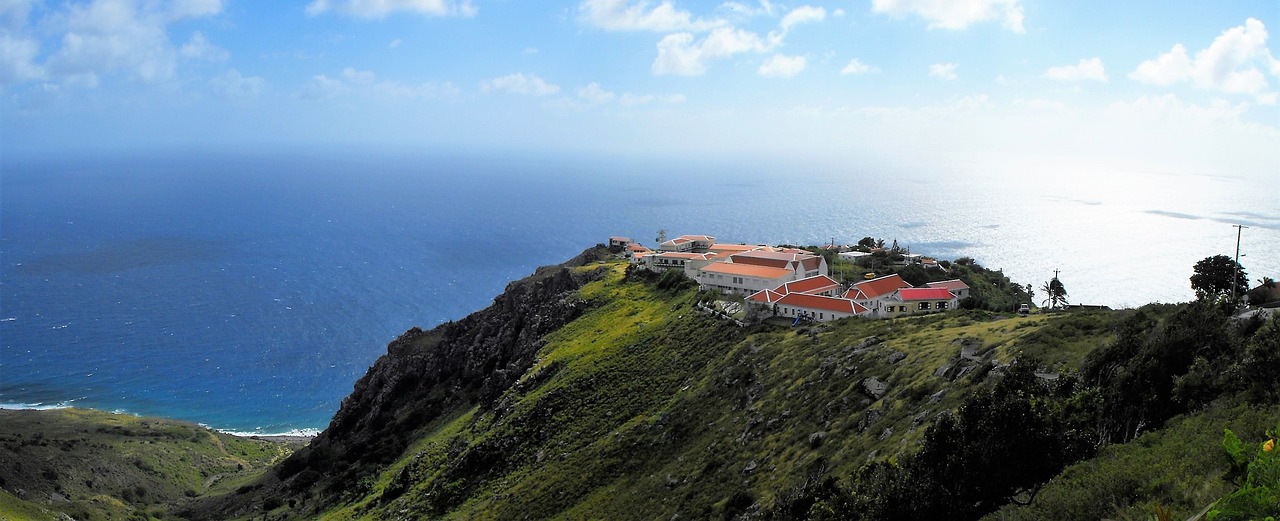
Saba is a volcanic island located in the Caribbean Sea in North America. It is part of the Netherlands, although it’s not part of the EU. Saba has a population of around 2,000 people (2024), about ¼ of whom live in the capital city, The Bottom.
The island is roughly circular and about 2½ miles (4 km) in diameter. Saba is the top of a dormant volcano, and the terrain across the whole island is mountainous. The highest peak is Mount Scenery, at 2,854 ft (870 m) above sea level.
The Saba Bank National Park lies off the coast of Saba. It’s the largest submarine atoll in the Atlantic Ocean and has some of the richest diversity of marine life in the Caribbean Sea. There are more than 20 species of whales and dolphins, sharks, sea turtles, over 200 species of fish, and many kinds of seabirds
Saba relies heavily on tourism like many other Caribbean islands.
A bit about the history of Saba
Early History and Indigenous People
Saba was originally inhabited by the Arawak and Carib peoples before the arrival of Europeans. These indigenous groups used the island for fishing and agriculture. However, there is little information about their specific settlement or lifestyle on Saba before the European discovery.
European Discovery and Dutch Control
In 1632, the Dutch claimed Saba, and it became part of the Dutch Caribbean empire. The island, due to its small size and rugged terrain, was less attractive to settlers compared to other Caribbean islands. It was primarily used for agricultural purposes, though it was largely isolated and not heavily populated.
Slavery and Economy
During the 17th and 18th centuries, Saba, like other Caribbean islands, was involved in the transatlantic slave trade. Enslaved Africans were brought to the island to work on small plantations, particularly in agriculture. However, Saba’s economy was less reliant on large-scale plantations compared to other islands in the region, and its economy remained primarily based on subsistence farming and trade.
Dutch Control and Political Changes
In the 19th century, the island continued to be under Dutch control. Saba, along with other islands in the region, was part of the Netherlands Antilles, a federation of Dutch Caribbean territories. The island’s isolation and small population meant it did not play a major role in the larger economic activities of the Dutch Caribbean.
20th Century and Modernization
Saba’s economy remained small-scale throughout the 20th century, with most people relying on agriculture, fishing and small businesses. The island’s infrastructure and standard of living gradually improved, especially with the development of tourism, which became an important sector in the latter half of the century. Saba’s unique topography and natural beauty attracted eco-tourists and divers, particularly due to its marine reserves and hiking trails.
Political Status and Integration with the Netherlands
In 1986, Saba became part of the Netherlands Antilles, a federation of Dutch Caribbean islands. When the Netherlands Antilles was dissolved in 2010, Saba became a special municipality of the Kingdom of the Netherlands, alongside its neighbours, Sint Eustatius and Bonaire. The island gained direct representation in the Dutch political system but remains a part of the Kingdom of the Netherlands. Today, Saba is known for its pristine natural environment, including Saba National Park, and for being a hub for diving and hiking tourism. The island remains an autonomous territory with a focus on maintaining its cultural heritage, protecting its environment, and developing sustainable tourism.

Saba road trip
Saba is our 15th planned stop on our Road trip through the islands of the Caribbean. Having explored Anguilla, our next stop is Sint Eustatius.
Travelling overland between the islands is quite prohibitive due to the lack of transportation options. Travelling between different island countries via ferry is possible, however, ferries only operate between some islands. Chartering private boats between islands is also possible, although travelling with a car in this way is prohibitive. Flying is another option, although again, flights only operate between some islands.
Map of our road trip through Saba
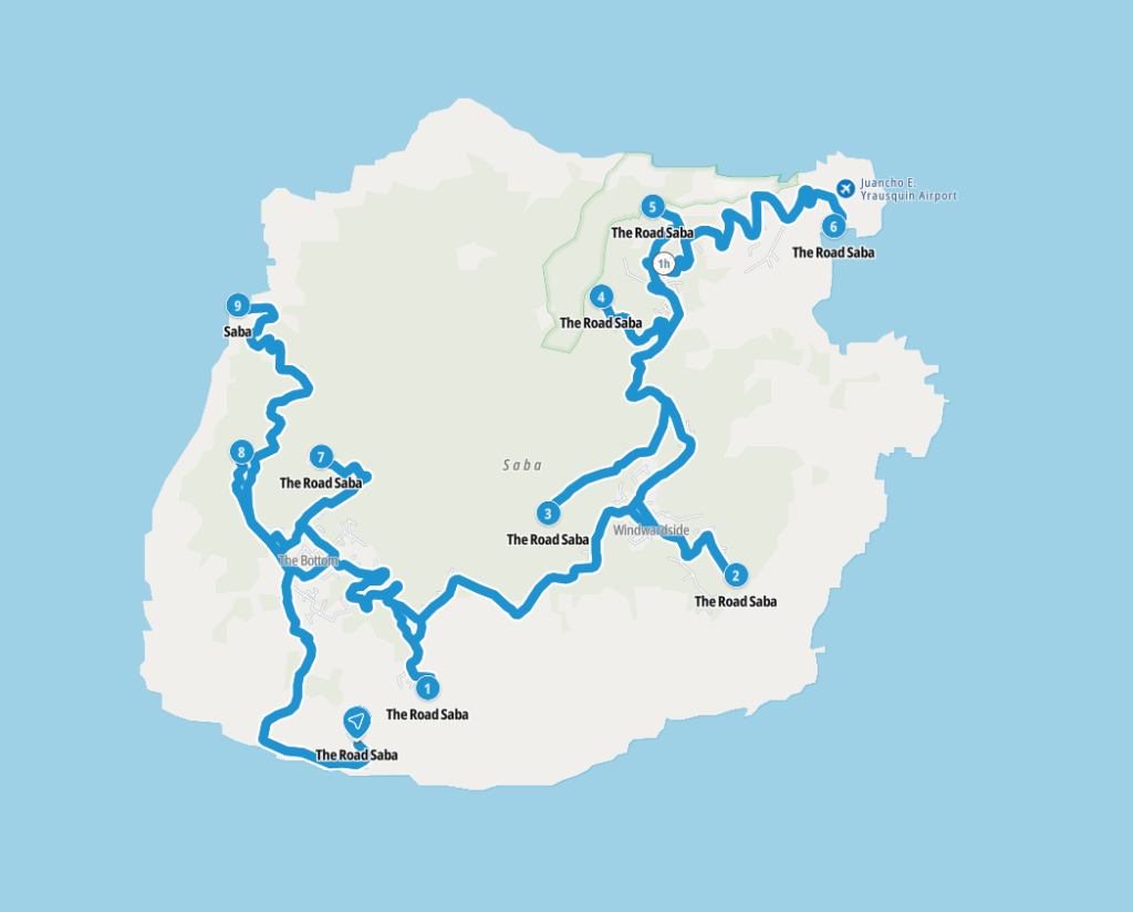
This is a map of our planned route around the islands of Saba, starting and ending in the port, Fort Bay.
Weather in Saba
When is the best time to visit Saba?
The best time to visit Saba is from January to May. During these months, the islands have 8-9 hours of sunshine per day and rainfall of 1.0 – 2.0 inches (26 – 51mm) per month. The temperature ranges from 24 – 31°C (75 – 88°F).
When is the worst time to visit Saba?
The worst time to visit Saba is from July to November. During these months, the islands still have 8-9 hours of sunshine per day. However, humidity rises and it rains an average of 2.8 – 5.3 inches (72 – 135mm) per month. The temperature ranges from 26 – 32°C (79 – 90°F).
Hurricane Season in the Caribbean
Hurricane season in the Caribbean runs from June 1 to November 30. Storms tend to be more frequent and more severe in the latter half of the season.
Hurricanes are least likely during December, January and February.
Travel in and around Saba
Ferries to other Caribbean island countries from Saba
Makana Ferry Services travels between Saba and Sint Maarten, Sint Eustatius (Statia) and Saint Kitts several times per week.
What’s it like to drive in Saba?
They drive on the right hand side of the road in Saba. There is only one main road on Saba, called ‘The Road’ 🙂 In the main, roads are in fairly good condition, with some smaller roads being dirt tracks.
Do you require an international driving permit in Saba?
We’ve created a dedicated page to driving abroad, which answers this question, and more, which you might find helpful.
Can you use your UK driving license when driving through Saba?
We’ve created a dedicated page to driving abroad, which answers this question, and more, which you might find helpful.
Do I need a carnet de passages to drive in Saba?
We’ve created a dedicated page to driving abroad, which answers this question, and more, which you might find helpful.
What are the speed limits in Saba?
The speed limits for cars in Saba are:
- 25 mph (40 km/h) for urban driving
- 35 mph (60 km/h) outside of built up areas
- 35 mph (60 km/h) on dual carriageways
- 35 mph (60 km/h) on motorways
What currency do they use in Saba?
In Saba they use the US dollar. Cash is widely used. The use of credit / debit cards is widely accepted in tourist areas. Travellers cheques are not generally accepted. There are many ATMs in tourist areas, although not all accept foreign issued cards.
You should make yourself aware of the amount that your bank charges you for using credit and debit cards abroad. Often credit cards are cheaper for purchasing items directly, and for withdrawing cash from ATMs.
What language do they speak in Saba?
They speak English and Dutch in Saba. Spanish is also spoken widely.
What time zone is Saba in?
Remember, when you’re planning your next trip to take a look at what time zone it’s in.
Do I need a visa to visit Saba?
We’ve created a dedicated, more comprehensive page on visas, which you should find helpful. Check it out!
Is wild camping legal in Saba?
No, wild camping is illegal in Saba.
What plug / socket type do they use in Saba?
In Saba they use plug / socket types A and B.


Health issues in Saba
Is it safe to drink water in Saba?
No, it is not safe to drink tap water in Saba. Bottled water is also readily available across the country.
What vaccinations are required for Saba?
This NHS website is kept up to date with all relevant information on vaccinations in Saba.
Phones in Saba
What is the country calling code for Saba?
The country calling code for Saba is +5994
What are the emergency phone numbers in Saba?
- The emergency number for police in Saba is: 911
- In Saba, the emergency number for ambulance is: 911
- The emergency number for fire in Saba is: 911
If you’ve got some useful info that you’d like to share, let us know!
And don’t forget to check out all the other pictures!