Mainland USA – Let’s explore here
What’s it like in the USA?
The United States of America (USA) is the third largest country in the world (after Russia and Canada), and has the world’s third largest population (335 million people). Forty nine of its 50 states constitute mainland USA, with Hawaii being located in the Pacific Ocean. It also overseas multiple other territories, including American Samoa, Guam, the Northern Mariana Islands, Puerto Rico and the US Virgin Islands, amongst others.
Although the USA possesses more wealth than any other country, the top 1% of earners take home 20% of the wealth, and the bottom 50% of earners take 10%.
The border with Canada is the longest in the world, at 5,525 miles (8,891 km) long. The Great Lakes which lie on the border with Canada are the largest group of freshwater lakes on Earth, containing 21% of the world’s surface fresh water by volume.
In the west of the country sits the Rockies mountain range, dividing the large plains in the east from the Pacific west. It extends north to south and is around 3,000 miles (4,800km) in length. Yellowstone national park sits in the Rockies and is around 3,500 square miles (8,983 km2) in area. Over half of the world’s geysers are in the park, as well as a super-volcano, Yellowstone Caldera.
In Alaska sits Mount McKinley (also known as Denali) – the highest peak in the USA, at 20,310 ft (6,190 m) above sea level. And in the north west of Arizona lies the Grand Canyon; with a depth of over a mile (1,857m), it is 277 miles (446km) long and at some points 18 miles (29km) wide.
A bit about the history of the USA
The history of the United States (USA) is marked by periods of colonialism, revolution, expansion, and conflict, ultimately leading to its emergence as a global power.
Colonial Period and Independence
The land now known as the USA was originally inhabited by Native American tribes. European colonisation began in the early 1600s, primarily by the British, who established colonies along the eastern seaboard. Tensions over British taxation and governance led to the American Revolution, and in 1776, the Thirteen Colonies declared independence, forming the United States of America. The Revolution ended in 1783 with the Treaty of Paris, recognizing the USA’s independence.
Early Republic and Expansion
The Constitution was adopted in 1787, establishing a federal government with checks and balances. The country expanded westward through the 19th century, acquiring territories through purchases, treaties and wars, such as the Louisiana Purchase (1803) and the annexation of Texas (1845). The Mexican-American War (1846-1848) resulted in significant territorial gains. During this period, slavery became a major issue, especially in the southern states.
Civil War and Reconstruction
The tension over slavery led to the Civil War (1861-1865) between the northern Union states and the southern Confederacy. The Union’s victory ended slavery and led to the Reconstruction era, which aimed to rebuild the south and extend civil rights to freed slaves. The period was marked by racial tensions and economic struggles, especially in the south.
Industrialization and Global Influence
The late 19th and early 20th centuries saw rapid industrialisation, urbanisation, and immigration, making the USA an economic powerhouse. The country’s global influence grew, with involvement in World War I (1917-1918) and later World War II (1941-1945), which positioned the USA as one of the world’s leading superpowers.
The Cold War and Civil Rights Movement
After WWII, the USA entered the Cold War, a geopolitical struggle with the Soviet Union, marked by conflicts like the Korean War (1950-1953), the Vietnam War (1955-1975), and the Cuban Missile Crisis (1962). Domestically, the Civil Rights Movement gained momentum in the 1950s and 1960s, leading to significant advances in racial equality, including the Civil Rights Act of 1964 and the Voting Rights Act of 1965.
Late 20th and 21st Centuries
The USA experienced significant political and social changes in the late 20th century, including economic shifts, the end of the Cold War, and the rise of the internet. The September 11, 2001 terrorist attacks led to the War on Terror and conflicts in Afghanistan and Iraq. In the 2000s and 2010s, the country faced political polarization, economic challenges (notably the Great Recession of 2008), and ongoing debates over issues such as healthcare, immigration, and climate change.
Today, the United States remains a global political, economic, and military power, though it faces challenges related to domestic inequality, political division and international relations.

Planned road trips
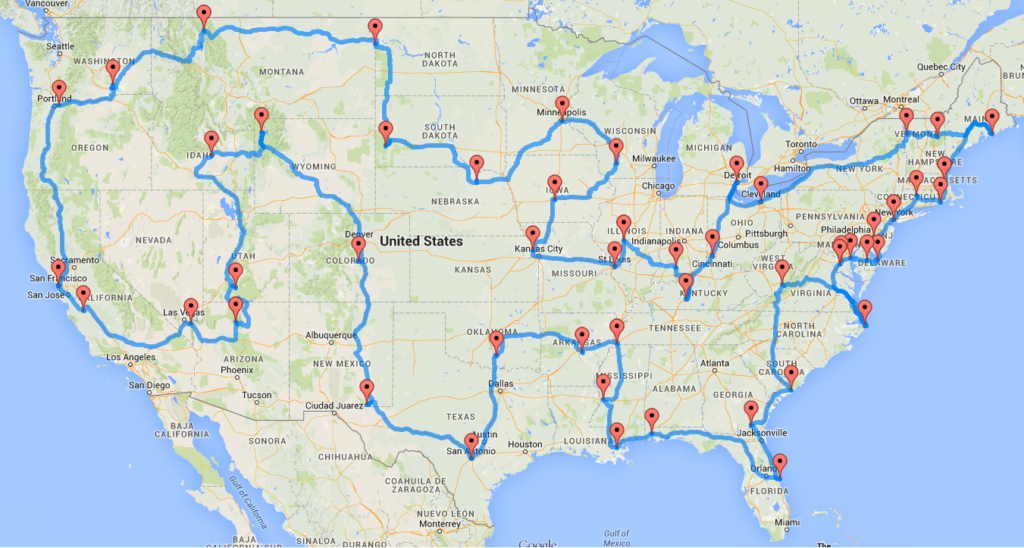
Road trip via United States landmarks
This is an optimised road trip travelling 13,699 miles (22,046 km) via the major landmarks in mainland USA. This map was created by Dr. Randal S. Olson, 2015.
Map of our road trip via USA landmarks
This is the list of landmarks:
- Grand Canyon, AZ
- Bryce Canyon National Park, UT
- Craters of the Moon National Monument, ID
- Yellowstone National Park, WY
- Pikes Peak, CO
- Carlsbad Caverns National Park, NM
- The Alamo, TX
- The Platt Historic District, OK
- Toltec Mounds, AR
- Elvis Presley’s Graceland, TN
- Vicksburg National Military Park, MS
- French Quarter, New Orleans, LA
- USS Alabama, AL
- Cape Canaveral Air Force Station, FL
- Okefenokee Swamp Park, GA
- Fort Sumter National Monument, SC
- Lost World Caverns, WV
- Wright Brothers National Memorial Visitor Center, NC
- Mount Vernon, VA
- White House, Washington, DC
- Colonial Annapolis Historic District, MD
- New Castle Historic District, Delaware
- Cape May Historic District, NJ
- Liberty Bell, PA
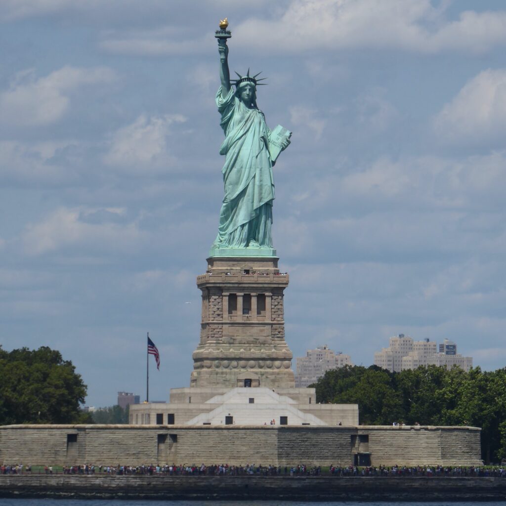
- Statue of Liberty, NY
- The Mark Twain House & Museum, CT
- The Breakers, RI
- USS Constitution, MA
- Acadia National Park, ME
- Mount Washington Hotel, NH
- Shelburne Farms, VT
- Fox Theater, Detroit, MI
- Spring Grove Cemetery, OH
- Mammoth Cave National Park, KY
- West Baden Springs Hotel, IN
- Abraham Lincoln’s Home, IL
- Gateway Arch, MO
- C. W. Parker Carousel Museum, KS
- Terrace Hill Governor’s Mansion, IA
- Taliesin, WI
- Fort Snelling, MN
- Ashfall Fossil Bed, NE
- Mount Rushmore, SD
- Fort Union Trading Post, ND
- Glacier National Park, MT
- Hanford Site, WA
- Columbia River Highway, OR
- San Francisco Cable Cars, CA
- San Andreas Fault, CA
- Hoover Dam, NV
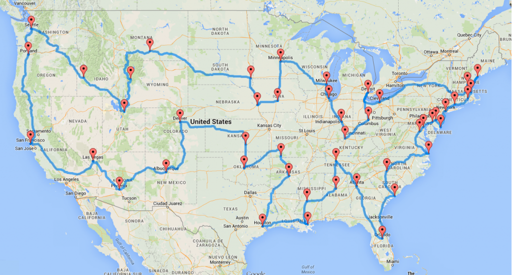
Road trip via popular cities in the USA
This is an optimised road trip travelling 12,290 mile (19,780 km) via the major popular cities in mainland USA. This map was created by Dr. Randal S. Olson, 2015.
Map of our road trip via USA cities
This is the list of cities:
- Oklahoma City, Oklahoma
- Wichita, Kansas
- Denver, Colorado
- Albuquerque, New Mexico
- Phoenix, Arizona
- Las Vegas, Nevada
- San Francisco, California
- Portland, Oregon
- Seattle, Washington
- Boise, Idaho
- Park City, Utah
- Jackson, Wyoming
- Billings, Montana
- Sioux Falls, South Dakota
- Omaha, Nebraska
- Des Moines, Iowa
- Minneapolis, Minnesota
- Milwaukee, Wisconsin
- Chicago, Illinois
- Indianapolis, Indiana
- Louisville, Kentucky
- Columbus, Ohio
- Detroit, Michigan
- Cleveland, Ohio
- Manchester, New Hampshire
- Portland, Maine
- Boston, Massachusetts
- Providence, Rhode Island
- New Haven, Connecticut
- New York City, New York
- Ocean City, New Jersey
- Philadelphia, Pennsylvania
- Wilmington, Delaware
- Baltimore, Maryland
- Washington, D.C.
- Virginia Beach, Virginia
- Charlotte, North Carolina
- Charleston, South Carolina
- Orlando, Florida
- Atlanta, Georgia
- Nashville, Tennessee
- Birmingham, Alabama
- Jackson, Mississippi
- New Orleans, Louisiana
- Houston, Texas
- Little Rock, Arkansas
- Branson, Missouri
Route 66
Route 66 was a road in the USA, made famous by a number of books and films, most notably one of my favourite books, ‘The Grapes of Wrath‘ by John Steinbeck, but also the films, ‘Thelma & Louise‘ and ‘Easy Rider‘.
The road underwent many changes over its lifetime, before the interstates eventually replaced it. However due to its cult status, it’s still a popular tourist route to travel.
Route 66 is around 2,450 miles (3,950 km) long, and travels through the states of Illinois, Missouri, Kansas, Oklahoma, Texas, New Mexico, Arizona and finally California.
Map of Route 66
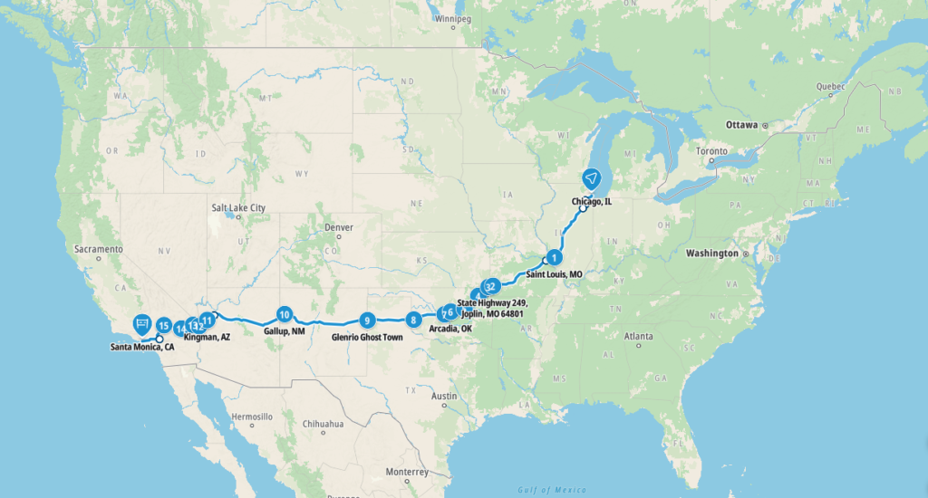
This is a map of the famous Route 66 in the USA that runs from Chicago, Illinois to Santa Monica.
Previous road trips
On our last road trip in the USA we travelled from New York and kept mainly to the north east of the country, in the States of Connecticut, Massachusetts, New York and Rhode Island.
Map of our road trip in the USA
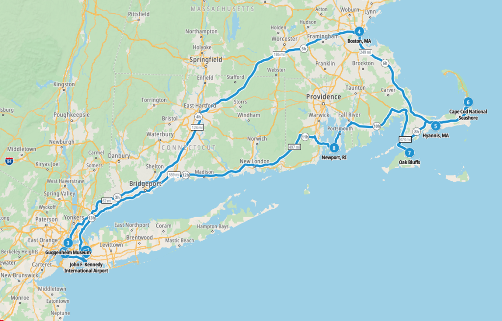
This is a map of our last road trip in the USA.
The route took us from New York – Boston – Hyannis – cape Cod – Martha’s Vineyard – Rhode Island – New York
Map of our road trip in the USA, from countrywide perspective
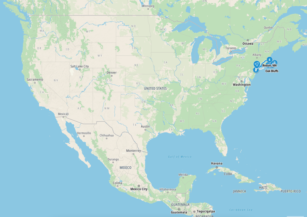
This is a map of our last road trip in the USA, with a view of all of mainland USA.
What’s it like to drive in the USA?
They drive on the right hand side of the road in the USA, and roads are generally in good condition. Driving is a leisurely affair due to the limited speed limits. Lanes do not appear to mean much in that you can overtake in any lane it seems! There are very few roundabouts and many very straight roads.
Drivers tend to have enormous cars, in comparison to Europeans, and they don’t tend to tailgate you.
We’ve also created a dedicated page to driving abroad, which you might find helpful 🙂
What currency do they use in the USA?
In the USA they use the United States dollar. Cash is widely used. The use of credit / debit cards is widely accepted . Travellers cheques are accepted in cities and tourist areas. There are ATMs throughout the USA, although not all accept foreign issued cards.
You should make yourself aware of the amount that your bank charges you for using credit and debit cards abroad. Often credit cards are cheaper for purchasing items directly, and for withdrawing cash from ATMs.
What language do they speak in the USA?
They speak mainly English, whilst many also speak Spanish in the USA.
What time zone is the USA in?
There are nine time zones in the USA and its dependencies. However, adding the time zones of two uninhabited US territories, Howland Island and Baker Island, brings the total count to 11 time zones. The contiguous mainland USA has 4 standard time zones. In addition, Alaska, Hawaii, and 5 US dependencies all have their own time zones.
Remember, when you’re planning your next trip to take a look at what time zone it’s in.
Do I need a visa to visit the USA?
We’ve created a dedicated, more comprehensive page on visas, which you should find helpful. Check it out!
Is wild camping legal in the USA?
Yes, wild camping is fine in many parts of the USA. Mainly, you can wild camp in US national forests and grasslands (unless otherwise marked), on Bureau of Land Management lands (providing they are suitable for camping and not being used for cattle grazing or mining operations).
What plug / socket type do they use in the USA?
In the USA they use plug / socket types A and B.


Health issues in the USA
Is it safe to drink water in the USA?
Yes, it is safe to drink tap water in the USA. Bottled water is also readily available across the country.
What vaccinations are required for the USA?
This NHS website is kept up to date with all relevant information on vaccinations in the USA.
Phones in the USA
What is the country calling code for the USA?
The country calling code for the USA is +1
What are the emergency phone numbers in the USA?
- The emergency number for police in the USA is: 911
- In the USA, the emergency number for ambulance is: 911
- The emergency number for fire in the USA is: 911
If you’ve got some useful info that you’d like to share, let us know!
And don’t forget to check out all the other pictures!